Transcript
Earthquakes and volcanoes capture our imaginations for the power they wield. But most of us are unaware that they are also connected to climate change.
Adam Smith: I’ve just stepped off my bike after cycling over solid tarmac to one of the may buildings at University College London. Nearby is Euston Station, through which hundreds of overground and underground trains pass each day, all relying on the fact that the ground doesn’t move – much. So I’ve come to UCL to meet the people for whom the ground does move a lot. The team here at the Hazards Centre, next to Euston Station in temporary accommodation at the moment, next to a giant building site, have found that climate change is actually having an impact on the very earth beneath our feet. I’m Adam Smith. Welcome to Pod Academy
So here I am in the UCL Hazard Research Centre, Earth Science – says the sign on the door. And you have to be specially buzzed in, but it’s not as if they’ve got any particular hazards going on inside, although there is a lot of building work on the outside. I’ve come here to meet Bill McGuire, who is the former director of the centre and for the past couple of years has just been continuing his own research, and Rick Wall, who is a Ph.D student looking at volcanoes and predicting them by sensing the earthquakes that happen in the run up to the volcano. Let’s just go through this door and see if we can see Bill.
Adam Smith: Bill, we’re here in your office and I can see lots and lots of bookshelves filled with books and journals and magazines and cupboards and lots of papers everywhere. Tell us a little but about the life of an academic in your field and what your day-to-day life is actually like when you’re here in the office.

Prof. Bill McGuire
Bill McGuire: Well I never think of what I’ve been doing since I was 21 as a proper job really because I did a PhD when I worked on Mount Etna on Sicily for three years, which was a little bit like a walking holiday with red wine and pasta when you had to do a little bit of research on the side.
And then I’ve been teaching and lecturing at various places and doing bits of research and now I’m at UCL and I still don’t feel like I’ve got a real job. I teach undergraduates to some degree. Most of my work involves lecturing the postgraduates studying at some level on our physical hazards programme. But I also teach people in the insurance industry. We run a course called Natural Hazards for Insurers, so we have people in suits coming in and learning about natural hazards because they’re insuring and re-insuring about these so it’s quite important.
AS: Can you tell us a little bit about the breadth of the research that goes on here and really what the mission is?
BM: Well the Hazards Centre has been going since 1997 and it was set up with sponsorship from one of the world’s big re-insurance companies, who are people who insure the insurers, so natural hazards are a big thing for them.
So we have people here working on all the main natural hazards from volcanic eruptions, on tsunamis… other people here look at aspects of disaster, risk production, mitigation, management. We have people working on all sorts of things – wind storms, floods. I was director from when it was set up until 2010 so I’ve stepped down and my colleague Chris Kilburn, whose office is next door actually, runs the centre but it still has the very strong links with the insurance industry and still has a breadth of research.
I would say in terms of our dominant area, it’s probably volcanic activity, volcano prediction, volcanic hazards, that sort of thing, that’s probably our key area. That may be along with wind storms, particularly tropical cyclone research.
AS: Climate change is affecting not just the atmosphere but also the solid earth?
BM: Well yes it is. It sounds a bit mad really that climate change can trigger things like volcanic eruptions and tsunamis, but this is absolutely true. It’s not speculation because we can look back in time to when the climate was changing very dramatically in the past and we can see this type of reaction.
For example, at the time of the last ice age, we had these huge changes in climate, the great ice sheets melted, sea levels rose 130 metres and you had massive changes in the stresses acting upon the Earth’s crust. So in places like Iceland, when the ice was removed you had a 50 per cent increase in volcanic activity. In places like Scandinavia, where the ice sheets were three kilometres thick, when they disappeared, the crust bounced back up by up to 200 metres or something like that. And that triggered major earthquakes. You had earthquakes in Lapland – in Santa’s grotto really – which were as big as the ones we see today around the Pacific Rim. So it’s something that we know from looking back is happening, has happened before and can expect to happen again.
AS: But how can you make the connection between what has happened in the past with regard to climate change causing earthquakes and things and what’s going on now with regard to anthropogenic climate change?
BM: Well, there’s two things really. First, if we carry on now in the sense that we don’t mitigate our greenhouse gas emissions then projections of temperature rise this century and sea level rise are going to be comparable to those we saw last ice age. And you could expect to see as a result of that some sort of geological reaction.
At the same time we’re seeing that reaction already. A place I call the ‘canary in the cage’ is the American state of Alaska because temperatures are rising very dramatically, very rapidly there. It’s a very tectonically active country with earthquakes and volcanoes and this sort of thing anyway and as ice is being lost from the great glaciers in Alaska, the crust is being lost and we’re already seeing an increase in earthquake activity. And it can be very nicely correlated with the loss of ice – the more ice you lose, the more the crust comes up, the more earthquakes you get.
AS: And these earthquakes you’re looking at now, are they really big ones or lots of small ones?
BM: Generally speaking the earthquake activity we’re seeing in Alaska is small scale. They’re small earthquakes on the whole, but there’s been one big one – magnitude 7 and plus – which is quite a big one. And that has been linked to the loss of ice.
In other words, it looks as if the reduction in load pressing down on that was just sufficient to allow it to rupture and generate that earthquake. It would have happened anyway but removing the ice seems to have brought the timing of that fault forward. And that’s the sort of effect that we would expect to see around the world where you have ice melting very rapidly and were you have active faults sitting underneath – those faults will have ruptured anyway at some point, but this will bring that rupturing moment forward so you will start seeing clustering of earthquakes in these sorts of areas.
AS: When we think about climate change we don’t tend to think of earthquakes, do we? Why do you think that is?
BM: Well, nobody thinks about earthquakes when they think about climate change because ‘climate’ means ‘the atmosphere’ to most people, and to some it means ‘the atmosphere and the oceans and the way they interact.’ And people just do not think that the solid earth beneath our feet has got anything to do with what happens in the atmosphere. But the evidence from the past is that there is a very close link. And it’s not surprising really, because we can look at examples from today of how very tiny changes can actually trigger responses in the solid earth.
There have been papers written in the last 10 years that earthquake activity in Japan reacts to the amount of snow that falls and how quickly that snow melts. Changing the load on the crust. You get earthquake clusters in Taiwan relating to the passage of storm systems, typhoons and the pressure they bring. So geological hazard systems are very, very sensitive to tiny changes in the environment. So when you get these massive changes in the environment as we’ve seen in the past and we may well see in the future, it shouldn’t be a surprise that you see that response.
AS: Where does the UK fit into this picture with regard to solid earth and climate change?
BM Well, the UK is geologically pretty stable – we’re not near any plate margins where you get the big earthquakes and the big volcanoes. The nearest one is the mid-ocean ridge that runs down the centre of the Atlantic Ocean, the Mid-Atlantic Ridge.
Probably the biggest direct threat to the UK from some response of the crust to climate change will come from tsunamis because one of the concerns is that if Greenland starts to lose its ice on a very rapid scale then the same thing will happen there as happened in Scandinavia in the last ice age. In other words, the crust will start to bounce back very rapidly and that will trigger big earthquakes and they have the potential to produce submarine landslides by just shaking great piles of sediment off, which slide into the North Atlantic and trigger tsunamis. It’s happened before. About 8,000 years ago there’s an event called the Storegga Slide where you had this huge landslide off the coast of Norway, shaken off by earthquakes as the crust bounced back.
And the tsunami generated by that was 30 metres high in the Shetland, it was six metres high in eastern Scotland, it went straight down the North Sea. It may have actually obliterated an area of occupied land called Dogger Land in the North Sea, which archeologists are now working on. People actually lived there because sea levels were reduced at the time.
AS: Let’s go out into the Atlantic now. I know that people in your line of work are really interested in La Palma in the Canaries. Can you tell us why that is?
BM: Yes, one of my areas of research since my PhD has involved the stability of volcanoes. Volcanoes get bigger and bigger over time. They become unstable and big chunks fall off them. The flanks collapse and you get these very large landslides. It’s a normal part of the life cycle of volcanoes.
Now, there’s a volcano on the Canary Island of La Palma called the Cumbre Vieja and it occupies the southern part of the island. It’s one of the most active volcanoes in the Canary Islands. It’s been getting bigger and bigger over hundreds of thousands of years. About 50 years ago there was an eruption, which was really quite a violent one for that particular island, but the particular thing about it is it generated a lot of earthquake activity and that earthquake activity was associated with the movement of the western flank of the volcano.
It slid about four metres downwards and then stopped. What’s probably happened there we think is that the west flank has been detaching itself for a period of time and this fracture surface has been developing at the base and that intersected the surface during that eruption so it separated the west flank from the rest of the volcano. And it’s continuing to move today, not at a great speed, but maybe a centimetre or two a year. Eventually that mass will collapse into the Atlantic. It’s nothing unusual. It’s a normal event over a period of geological time. So it will happen. We don’t know when it will happen, but it will generate a very large tsunami. Which will be enormously destructive in the Canary Islands. There’s a big debate about how large the waves will be when they reach the other side of the Atlantic – whether they’ll be 10 or 20 metres high or maybe just a few metres high.
AS: Could we see Manhattan under water?
BM: If the waves are 10 to 20 metres high, the destruction level will be massive, obviously. Even if the waves are four to five metres high, which don’t sound great, I think people need to remember that in the Indian Ocean tsunami, many thousands of people in Thailand and Sri Lanka were killed by waves of that height. So even four or five metres high will cause a huge level of destruction. If we’re dealing with one to two metres then things won’t be particularly bad.
There’s a lot of debate. It’s all related to how quickly the energy will be lost across the Atlantic – there’s a lot of argument about that and I don’t think any argument will be lost until the thing collapses and we find out.
AS: That’s the thing, isn’t it? Can you actually predict how this thing would happen?
BM: Well, we’ve never seen a volcano collapse slowly. Every time volcanoes collapse, they collapse catastrophically. They generate these huge landslides, which are called sturzstroms, which move very quickly – 100 metres a second. That’s about the same speed as a Formula One car going as fast as it can. So it’ll go very quickly, which transfers energy into the water. There are issues that relate to how big the tsunami will be, how big the mass that collapses is. The maximum size is 500 cubic kilometres, but it could be smaller. That’s obviously going to determine the size of the wave to some extent. The key thing in terms of the other side of the Atlantic is how that wave travels and there are different models which predict dissipation at different rates and that’s what the argument’s about among the scientific community and we won’t know until we see it happen.
AS: You made a BBC Horizon programme about this over a decade ago. Can you tell whether we are any closer to it actually happening?
BM: Yes, I think it’s 12 years since the Horizon programme, which is still being repeated around the world because I still get emails from people saying, ‘Are we in danger?’, from Brazil or the Caribbean. Since then a number of things have happened. A paper was written by colleagues of mine the year after which suggested that the waves would be devastating when they hit the North American coast and the Caribbean. And that generated a huge amount of argument because a lot of modellers said, ‘I don’t think that’s going to happen, it’ll be much smaller.’ But there have been a number of papers since then which have supported the fact that this will be a catastrophic event, locally and the other side of the Atlantic. So that has progressed to some degree.
Also, monitoring the volcano has shown that this movement is still occurring. So we now know with certainty that the west flank of that volcano is moving differently from the rest of the volcano and it’s continuing to slide. We don’t know when it will collapse – it could be in a year’s time, it could be several years’ time. But we would expect it to do it during an eruption because during an eruption you would have a lot of ground shaking and that’s a good way to shake off an unstable mass of rock.
You would also have new magma pushing up inside the volcano. That provides a physical shove as well, sideways because this is a big long volcano, the magma pushes up sideways along a ridge. And of course that magma intrudes into the water table and where you have that sort of situation, the magma heats up the water, which expands and adds an extra push. So ideally this thing would go during an eruption, but we don’t know when the next eruption is going to be either, so we’re no closer to knowing than we were 10 years ago.
AS: On the other side of the world, in the Pacific, you’ve been looking at the solid earth with regard to El Niño.
BM Yes, the El Niño research relates to this fact that small changes in the environment can actually trigger tectonic events. And what we’ve found on the floor of the Pacific is that you have a certain amount of seismic activity – small earthquakes happening – pretty much all the time because it’s a very tectonically active area. But it seems that seismic activity increases when the water level is reduced even by just 10 or 15 centimetres. And this happens before El Niño conditions develop. What happens with El Niño is that warm water in the western Pacific will flood towards the east and so you get these warm waters developing in the eastern Pacific, which has ramifications worldwide for climate and weather.
But that movement of the east raises the water level by a few tens of centimetres. But before that happens the water actually shoves off to the west, so in the east you get this reduction in the level of the ocean by maybe 10 to 15 centimetres and that seems to correlate with the earthquake activity in the eastern Pacific. So we might be able to monitor this activity. If you see an increase in earthquake activity that’s statistically significant, that may tell you that you’re in this pre-phase when the water’s shoved towards the west and it will eventually come all the way back again as El Niño. So it’s a great example of tiny changes in environmental conditions affecting the solid earth that might prove useful.
AS: In an ocean as big as the Pacific, how do you go about measuring a change in sea level of 10 to 15 centimetres – do you just go out there and stick your ruler in?
BM: Fortunately we don’t have to do that because there are satellites up there that will do it for us. There’s a satellite called TOPEX/Poseidon which monitors sea level across the globe, so you can get your data from that, which is what we’ve done.
AS: You’re involved a lot in advising governments and international organisations with regard to natural hazards. Why do you think that’s important and why do you do it?
BM: Two reasons really. Firstly, humanitarian – there are many more people being affected, many more people dying as a result of natural catastrophes and also they’re costing a lot more. Year on year the cost of natural catastrophes goes up – last year it was getting on for a third of a trillion, maybe more than that, because we had the Japan earthquake and tsunami, very costly. So as the Earth become more populated, as more people live in mega cities and vulnerable areas, governments want to know what the risks are and how they can cope with those risks and how they can prepare in advance.
AS: Do governments listen?
BM: Well, they sort of listen. To some degree. For a while. I think a prime example is the Indian Ocean tsunami in 2004. That really concentrated people’s minds because it affected not only the populations of developing countries but also people who were on holiday, tourists from all over the world in Thailand and Sri Lanka especially.
Tony Blair asked David King, who was the Government’s chief scientist then, to set up a Natural Hazards Working Group, of which I was a member. Our report recommended that we needed to set up some sort of international science panel who could identify these areas of the world where there was specific threats because in many cases scientists know that the threats are but they’re either not communicated to the people who need to know or the people that need to know aren’t paying much attention.
The Indian Ocean tsunami is the perfect example. Kerry Sieh, who’s an American geophysicist who worked out there, he was using his own money to tell people about the threat – producing leaflets and so on – because he knew there was a massive earthquake waiting to happen. And that shouldn’t be the case. Governments should know what the threat is and they should be acting. This idea was actually presented by Tony Blair at a G8 meeting in Gleneagles a few years later, 2005 I think it was, and then the UN thought ‘this was a good idea, we’ll take it on board’. But to be honest nothing has happened since. We still don’t have a panel pinpointing these threats.
AS: Politicians not listening much? Sounds like they’re far more predictable than earthquakes and volcanoes, doesn’t it? But I’m going to go and ask Rick Wall about that because he’s just a few doors down, I understand, and he’s doing his Ph.D in forecasting volcanoes. Bill McGuire, thanks very much for taking the time – it’s been really fascinating to hear all about these amazing things that are going on underneath our feet and in our oceans.
BM: You’re very welcome – and don’t forget to buy my book!
AS: I’ve come down the corridor from where Bill McGuire’s office is and I’ve come into a bigger room with a few more desks and chairs and there’s lots and lots of paperwork and old manuscripts and books and folders and computers everywhere. And I’m here with Rick Wall, who’s doing his Ph.D here looking at volcano prediction by looking at the seismic activity that goes on around volcanoes. Rick, can you tell us a little bit about how you can go about using the seismic activity around a volcano to predict whether it will erupt.

Rick Wall
Rick Wall: When a volcano erupts, you have a magma chamber or magma dikes which inflate the edifice so magma coming up causes inflation of the volcano itself and the inflation we see is deformation, and that’s what we measure before volcanic eruptions.
AS: And how do you go about actually measuring the earthquakes? Are we talking about that thing we’ve all seen on telly where it’s a big roll of paper with a needle skittering back and forth?
RW: It is actually that. Many networks of volcano observatories place seismometers around the volcano and they detect the wave forms that come from each earthquake and they can locate each earthquake to get the size and depth of each earthquake that occurs.
AS: So one thing I’ve always wondered: does that mean that people like you end up with a huge roll of paper with a wobbly line on it?
RW: That is what you get in a lot of cases, but I don’t deal with looking at the raw data. I ask the observatories for their eventual catalogue which is a list of dates, times, magnitudes of earthquakes, the locations and the depths, so I don’t actually deal with just the raw wave form data, but that does happen, yes.
AS: I’m sitting by your desk and I can see there’s a pad with some graph paper on it and some notes there and some lines and on the computer there’s what looks to be fairly complicated scatter graph with lots of dots and numbers all over the place. So what do you go about doing with that data you receive from the observatories?
RW: The best way to do it is to look at the earthquakes in time series and look back from the actual eruption, so these are earthquakes where I’ve looked at the time of the eruption and then gone back before the eruption to see, as a first order, just the number of earthquakes before an eruption. Then I can also go back and look at how the earthquake’s changed, if there was a spatial rupture before the eruption or if there was a concentration of depth and then I can infer if there was magma moving there or that was a particular stress concentration, so that’s what I usually do with seismic data.
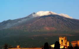
AS: I know you’re interested in Mount Etna in Sicily. Have you been there?
RW: Yes, I’ve been twice with the Open University as part of the ground deformation study. I’ve been two weeks each year in 2010 and 2011.
AS: And what are your memories of going there as a researcher who is studying this thing?
RW: It’s absolutely fantastic to be able to see a volcano that’s actually quite active. So you’re able to see all the structures you’ve been reading about and everything you’ve been learning about the volcano. You can see in real time, so you get to see all the fractures, all the cones. Etna always has a small plume coming off it, so you can see all the gases. And it’s great to actually see this happening rather than just reading about it.
AS: Have you been there when it’s been erupting?
RW: I have been when it’s in an episode of eruptive activity, but sadly I missed the eruption because I was on the opposite of the volcano in a thunderstorm. What we actually heard was a thunderstorm but also the volcano erupting, but I didn’t realise this till I got back and I had a friend in London say to me, ‘Please tell me you got pictures of the eruption,’ and I had to say, ‘What eruption?’ I had no idea, even though I was there!
AS: So an eruption does sound like thunder and thunder does sound like an eruption?
RW: Yes, well it was just very similar. I couldn’t really tell either or. It was only because I came back and realised that there was an eruption, I realised that the bangs must have been part of the eruption as well. It sounds almost like a rock fall and you wonder what it is and you look up and there’s usually a plume coming out of the volcano.
AS: Can you do the sound?
RW: I can’t do the sound, it just sounds like a [makes sound]. That’s the best I can do!
AS: You obviously have a very specific relationship with a volcano like Etna having scrutinised it and studied it. What do the locals make of it?
RW: It’s always very interesting to go because we always stay in one of the local towns in Etna and they actually seem to know a lot about the volcano. They’re always keen to know what’s going on. If they know you’re doing work on it, they’ll always say, ‘Oh, do you know anything new?’ But of course because they live on it, they know an exceptional amount about the volcano and what it can do because they see it every day from their houses, they can just look up and see what the volcano’s doing that day. So it’s really nice to see that they’re interested in what’s going on.
AS: The public in general is becoming more and more interested in volcanoes, especially since the Icelandic eruption a couple of years ago. First of all, can you pronounce the name of the volcano in Iceland that erupted?
RW: I’ll give it a go. I think it’s ‘Eyjafjallajökull’.
AS: That sounds great – much better than I can do! Do you think because of eruptions like that the public is becoming more aware of volcanic and geological activity?
RW: It seems to be, yes, that everyone is more aware and clued up about it. I have a lot of friends who ask about volcanoes when they’re erupting. In fact a lot of time I’ve had friends tell me that a volcano’s going off and I’ve had to ask where it is and what it’s doing. You find that people are more aware of what they [volcanoes] can do – especially ash in flight.
People are generally more interested in what’s going on and they also seem to realise now that at any one time there’s a lot of volcanoes erupting on the Earth whereas before I don’t think people realised what eruptions were occurring and how big they were.
AS: It’s like Hamlet. There’s always one performance of Hamlet on stage somewhere on the Earth at any one moment in time. Bill did his Ph.D on Etna as well a few decades ago. Here I am sitting in front of your computer with all of your charts and graphs and calculators and things. How do you think that technology has changed how people like you manage to do your work?
RW: Technology’s improving all the time and you do realise just how much more sophisticated all the equipment’s becoming and having looked at literature from the 80s and 70s, you realise just how lucky we are at the moment to have such amazing equipment and it’s still getting better. It’s still getting more sophisticated. Everything’s improving and that just helps so much more in prediction. You get so much more of a feel for what the volcano’s doing and it’s just fantastic – in every department, gas, seismics, ground deformation, you can pick up smaller movements, you can pick up smaller trace elements. Everything’s becoming more sophisticated.
AS: Well, I’ll let you get back to your work, Rick. It looks like there’s lot of papers to sort through and calculations to be made. Thanks a lot for taking the time to talk to us about this really interesting research.
RW: Thank you.
…………..
I’m back on the street now outside the Hazards Centre and I don’t know whether I should be alarmed by the power of the earth beneath my feet or satisfied that we’ve got some bright brains studying it. Before I leave you to ponder that, here’s the final question I asked of Bill.
AS: What is the one thing that would put folks like you out of busines?
BM: A very large asteroid impact that wipes us all out! That would put us out of business!
This podcast was presented and produced for Pod Academy by Adam Smith.
Notes
Useful links and suggested reading
Organisations
- British Geological Survey
- Edinburgh Geological Society
- The Geological Society
- Geological Society of the America
- Intergovernmental Panelon Climate Change
- Leeds Geological Association
- Open University Geological Society
- Skeptical Science
- UCL Hazards Centre
- US Geological Survey
- Start a geological society in your school – advice on setting up a society where students can mine for information!
Bill McGuire
- Waking the Giant by BillMcGuire
- Global Catastrophes: A Very Short Introduction byBillMcGuire
- Bill McGuire’s Homepage
Geological activity
Articles and papers
Tags: Bill McGuire, Chris Kilburn, climate change, Earthquakes, El Niño, Etna, Eyjafjallajökull, Iceland, La Palma, Natural Disasters, Open University, Rick Wall, Storegga Slide, tsunami, UCL Hazard Research Centre, Volcano
Subscribe with…